Monday, November 15, 2010

Joshua Tree National Park aka "Epic Beauty, Foolish Girl"

Valleyview


If you're one of the three or four people who read this blog, you may recall that my brand new love affair with the desert sprouted last January during a magical camping trip to the Mojave.

Unfortunately, I've been a bad lover.

Blame it on summer heat and this year's vaguely obsessive (yet successful!) quest to summit Mt. Whitney, but I haven't been back out to the land of cacti and tumbleweed since the Mojave trip. So when summoned out to the patchouli-and-marijuana-scented environs of Pioneertown, just north of Joshua Tree, for a friend's dude ranch birthday bash, I decided to take a dip back in the sand.

After some yummy ma 'n pa cookin' at Crossroads Cafe and Tavern, I stopped at the ranger station, bought a somewhat mediocre map, loaded up my buddy Casey's informative write-up of the general area I wanted to hike, and set forth on my adventure.

I chose the relatively newly created North View / Maze / Windows loop for both the solitude (it's not in guidebooks) and the scenery (epic ridges, canyons, and rocks for days), and not a minute away from my car, I stared slack-jawed at giant stone temples and gnarly old Joshua Trees, babbling to myself about how fucking awesome nature is (true) and how fucking great it is to be alive (true).

Pyramid


Entranced by the desert and her siren ways, double-fisting my iPhone and Canon to catch every little windswept boulder and cottonball cloud, I didn't know that I was off trail until I nearly stepped off a ledge into a small slot canyon below. I studied it. I studied my map. I studied it. Hmm. Hmpf. This was not the trail.

I backtracked and then I saw it, a thin dirt path leading up through some rather chunky rock formations. Apparently, I was so mesmerized that I wandered right past it, over a rather obvious "waterbar," and nearly right into some trouble. Clearly, the desert requested a bit more focus, so I slugged some water, adjusted my sunglasses, and focused my way up, up, up until I reached the really incredible valley pictured at the top of this entry, and then I cackled out loud at the sheer magnificence of it all, and the sheer insignificance of myself in its midst.

Sentinels


Phalli


Swirls


I danced around here, completely alone, in giddy, wondrous euphoria for a long time. A long, long time. So long, in fact, that when I checked the time on my phone, I realized that I'd gone maybe just under two miles in an hour's time, due to my off-trail exploits and rock worshipping, and was due at the ranch in an hour for dinner.

Not wanting to backtrack, I stowed the camera gear and picked up the pace, running downhill into a wash, then back uphill along some switchbacks, passing one trail junction for a viewpoint, then another. Suddenly, I found myself at the top of a ridge, gazing down at the wide desert valley, once again cackling with glee, until I realized that the trail just ended. Stopped. Went. Nowhere.

Crap. Crapcrapcrap. I peered back into the valley and saw my car, checked my compass, and picked my way along the ridgeline, figuring the trail must ride along the top for a bit until dipping back down below.

It didn't.

Instead, in my haste to bust booty back to the barbecue, I mistakenly took the second viewpoint turnoff, leaving the main trail. From my erroneous perch, I saw the trail ribbon through a valley behind me, and was able to reason my way back to it, suddenly not enjoying my desert adventure as much anymore.

This is the part of hiking that I usually name the "Get Me Off This Mountain" phase of the adventure, except now it was "Get Me Off Of This Godforsaken Sunburned Swath Of Sandy Misery." I was walking so quickly that it almost qualified as running. I cursed my sense of adventure. I cursed the Stabby Little Asshole Plants along the trail. I found myself fixating on thoughts of rattlesnakes. And tarantulas*. And mountain lions**.

Then I wandered into the wrong wash twice, backtracked twice, followed some footprints to a dead end, backtracked, and almost cried. Then my phone rang, and it was my friend David, asking me to stop and pick up some assorted meat products for the barbecue, and then I laughed at what a freakin' idiot I was being in the most beautiful place I've ever been.

Barren


* Two weekends ago, I finally saw a tarantula. My friend screamed as though she was being skinned alive and pointed at this hulking furry beast crawling up a rock on the side of the single track leading up to Bear Flat. I'M SO GLAD I DIDN'T SEE ONE OF THESE ON THE TRAIL IN JOSHUA TREE. I would have cried then, for sure. Serious tears. WHY ARE THEY SO LARGE??? Come on, evolution - throw a girl a bone here.

** The following day, I took off on a 6-mile hike from the Black Rock Campground, in the Northwestern corner of the park (not realizing until afterwards that this was exactly where that dude got lost for a week), shitty National Geographic map in hand, and had to step over a fresh, steaming pile of mountain lion crap about four miles in. I threw my hands above my head, acted big, and sang Aretha Franklin very loudly and very off-tune for about a half mile, until my heart attack subsided and I was able to enter the "Get Me Off Of This Godforsaken Sunburned Swath Of Sandy Misery" portion of my three-hour tour.


What Would Ed Do?
Ed would probably study trail write-ups a bit more closely, and would certainly not use the shitty, poorly detailed National Geographic map of the area. He would probably also tell someone where he was going, lest he become part of said fresh, steaming pile of mountain lion crap***. He would also have no use for the trail, and thus would not become lost, because he would just shimmy up and over the rocks like a very tanned Spiderman.

*** I'm kind of glad I didn't see 127 Hours until after this series of hikes

[Shawnté]

Monday, September 6, 2010

Mt. Whitney aka "Hallelujah!"

Sight for sore eyes!


No more numbers, no more statistics.


During last week's Mt. Whitney adventure, I realized that for me, hiking is not about calculations or measurements or stopwatches, mileage accumulated, altitude gained - it's about truly living in the moment.


And what a moment!


To begin...

Mt. Whitney burrowed her big granite self in my gut about a year and a half ago, thanks to a sudden devouring of mountaineering literature, courtesy the outdoorsy aisle at Portland's print utopia, Powell's Books. I convinced some friends to join in my growing Sierra fever, and after winning an overnight permit in the somewhat bureaucratic lottery process, I busied myself with physical and mental preparations - lots of mileage and elevation and presentations and message boards and books and gear and early morning runs.


Even so, it snuck up on me. With only days left until our departure, I frantically ransacked REI and Adventure 16, gathered up every stitch of SmartWool in my closet, and purchased an asinine amount of Swedish Fish. I packed, then re-packed, and then stared at it all for a good long while.


And then we hit the road.


***


As viewed from the Eastern Sierra Inter-Agency Center


Three expertly crafted mix CDs later, we rolled into the Eastern Sierra InterAgency Visitor's Center to the anthemic strains of "One Moment In Time." We belted along with the lesser Whitney, until we stumbled out of the car in a daze to stare incredulously at her more luminous sister, jutting out of a distant alpine scene across US 395. Gobsmacked, I ran to the edge of the parking lot, loaded up with camera in one hand, iPhone in the other, snapping away in awe.


The familiar sawtooth ridge was unmistakable. I can't believe we're really here.


After a quick stop inside to retrieve our permit, pack tags, and WAG bags, we shoved all of our food and scented items into our bear canisters to avoid being jumped by what the Whitney message boards described as some verrrrry hungry mama bears loitering around the campground we'd be staying at that evening. This is also when I began compiling a private mental list I referred to as Things I Hate, something I'd add to frequently in the final few hours of our trip. [#1 - BEARS EATING ME SO THAT THEY CAN THEN EAT MY FOOD]


Leaving the Visitor's Center, we breezed through tiny Lone Pine, and angled up Whitney Portal Road, the Hallelujah Chorus of Handel's "Messiah" blasting through my speakers, cheesy grins slapped across our faces. One hairpin turn and thirteen quick miles later, we found our campsite at the Whitney Portal Campground, and stared slack-jawed at our surroundings - fatty pine trees, house-sized boulders, cascading streams...and not one hungry bear in sight. Hello, paradise! Hello, nirvana!


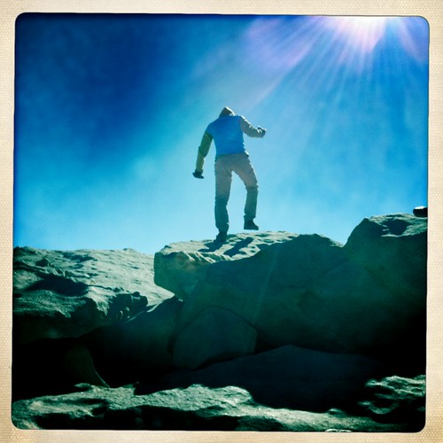
Cautious, we shoved every single thing we brought into the bear locker, ran around in a fit of delirious photo-taking, then headed up the mile-long recreation trail to the Whitney Portal itself. The altitude (8000') left us a bit winded, but we slowly wound our way alongside the creek, shouting out things like "This place is so freaking gorgeous!!!" and "Oh my god, I can't believe we're really here!!!" every minute or so, enamored by the emerald swimming holes, never-ending waterfalls, and epic bouldering opportunities left and right.


Gorgeous granite


At some point, Casey said, "This place is a destination in and of itself," something we'd repeat too many times to count in the days to come. This is when I started to realize that despite what we heard to the contrary, the Main Mt. Whitney Trail might actually be...awesome.


To the casual reader, I suppose this sounds confusing - why wouldn't it be awesome? This is the Eastern Sierras, after all - it should be all Handel's Messiah and '80s pop anthems and foaming at the mouth...


Except that every single printed word, every online exchange, every oratory tale we internalized about the Main Mt. Whitney Trail (MMWT) was that it generally sucked: Hordes of hikers, knee-wrecking granite steps, general eau de piss, never-ending switchbacks, deranged marmots.


Maybe we were just lucky, but we found absolutely none of this to be true. In fact, quite the contrary...


***


Whitney Portal Store


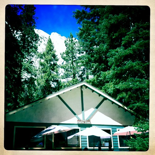
In the morning, we padded over to the Whitney Portal Store and hungrily eyed the simple menu. I opted for an overflowing plate of egger/hashbrown, while the rest of our party took a chance on Pancake. Yes...Pancake. Singular.


When Pancake came out, he came loaded onto three plates to support his massive circumference. Still, the force of hunger was strong, and while I tucked into my own epic portion, they were taking fork and knife to theirs. Laura and Rebecca split Pancake, eventually leaving him in a crumbling mess spread across five plates. Casey began excavating the center of Pancake, but quickly capitulated to the fluffy behemoth. But Tim held his ground, methodically shoveling in forkful after forkful of Pancake, until his plate was clean and his face was bulging in pain. Tim won breakfast; a true hero among men.


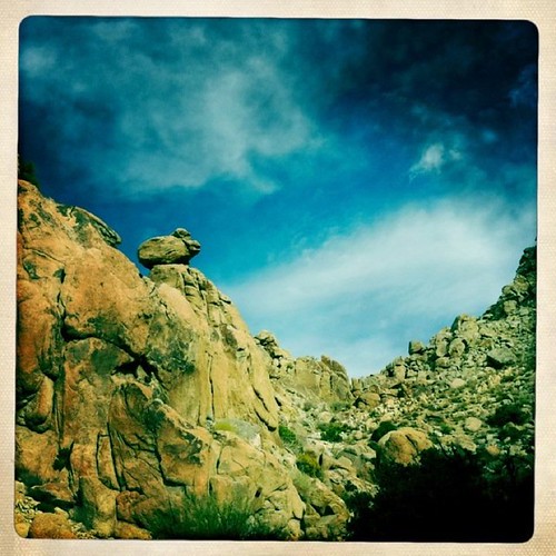
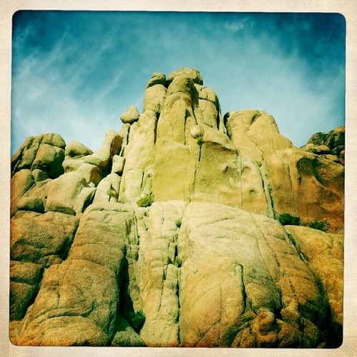
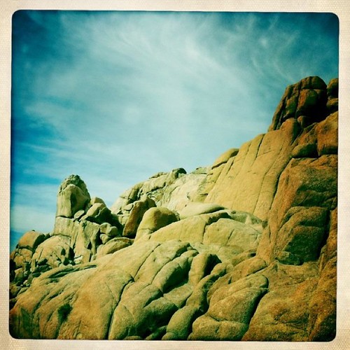
After a brief recombobulation pit stop in Lone Pine and a goodbye to Pancake-stuffed, Yosemite-bound Tim, we rolled through the Alabama Hills and scampered around a bit on the incredible rock formations there (including yet another utterance of "This place is a destination in and of itself.") Then we began the slow 7000' climb up to Horseshoe Meadows...and SNOW.


SNOW!


It was cold at Horseshoe Meadows. Freezing. Frigid. We layered on every stitch and still wished for more. I began to fear our upcoming night at Trail Camp, even higher at 12,000'. Stamp collecting...becoming appealing. [THINGS I HATE #2 - SNOW WHEN I'M CAMPING]


With frozen fingers, we quickly set up camp in a rather uninspiring site located off of the main parking lot, got in a quick nibble, and then assessed the complete overabundance of food we'd hauled up the mountain - successfully parsing out our ten tons of grub turned out to be the biggest challenge of the entire trip, leading to some tense moments and fearful flashbacks to the Chilnualna Falls trip. Suffice to say, none of us suffered from starvation on this trip.


Wilford Brimley?!?!


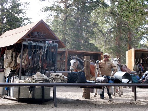
A late afternoon stroll took us to a horse-filled pack station attended by a man who can only be described as Wilford Brimley in chaps, a meeting with a scampy little trail dog, and a stroll across a very un-meadowlike meadow leading to a surprise encounter with three very large, very ornery-seeming, very wild cows. Cows. COWS. [THINGS I HATE #3 - BEING TRAMPLED ON A MOUNTAIN BY A PACK OF RABID WILD COWS]


While Laura braved crossing the hoofed beasts to attain some nearby pass, the rest of us beat it back to the campsite, and after some dinner and unsuccessful fire-starting, we retreated to our tents to recharge for the next day's ascent.


***


I woke up intermittently throughout the night, a mixture of excitement and really having to pee. [THINGS I HATE #4 - PEEING OUTSIDE WHEN IT IS ANYWHERE BELOW 65 DEGREES OUT] When I finally slunk out of my sleeping bag, I scraped against ice on the inside of the tent, thought once more about stamp-collecting, and eased myself out into the cold.


After a slow-moving morning, we barreled back to Whitney Portal, scarfed down another delicious breakfast (minus Pancake; lesson had been learned), and finally hit the trail. Once we crossed the John Muir Wilderness boundary, it was all brand new. Right away, we started up a long series of lazy switchbacks, and the higher we climbed, the wider the vista spread out below us - the Inyo Mountains, the Owens Valley, Lone Pine, and Whitney Portal. We marveled at the excellent construction of the trail (mad props, trailbuilders!), gawked at the scenery, and enjoyed a leisurely pace.


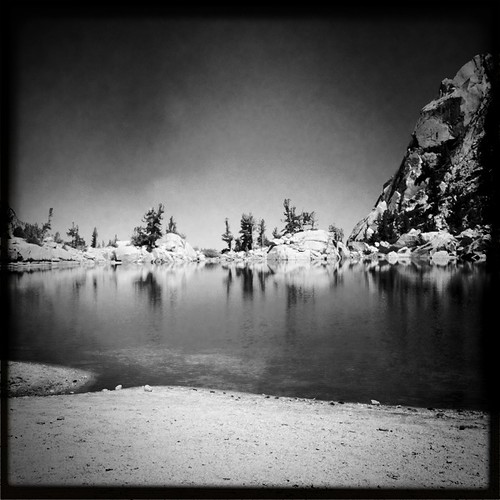
It wasn't until we came to the Lone Pine Lake junction, though, that the grandness smacked us on the ass. We could glimpse a bit of sapphire-blue water through the trees, and while I went to find a lofty pee perch, my friends went to investigate. [THINGS I HATE #5 - PEEING ON MOUNTAINS] When I joined them, I almost collapsed - Lone Pine Lake is basically a completely still, flat, blue mirror hanging right on the edge of the mountain, giving it the appearance of an alpine infinity pool. After a few spastic laps across the shoreline, I collapsed with a Snickers bar and a very, very satisfied grin.


Lone Pine Lake


From here, the trail turns into permit-only territory, and let it be said that neither on the way to Lone Pine Lake, nor on the way from the lake towards Trail Camp did we see more than a handful of people. We had the mountain practically to ourselves, a feeling that's incredibly hard to describe. For the time being, it was our mountain. Or at least, it let us think that.


After a few more switchbacks, the trail took a dip down and dropped us into magical fairytale land - Bighorn Park, a place that barely registered in all of our pre-trip recon. But it was one of the most magnificent sights on the entire trail - a wide swath of fluorescent green wetland, flanked by granite sentinels all around.


View from Bighorn Park


Sailing on our alpine high, we crossed into Outpost Camp, which was nearly empty, nary a whiff of pee to be smelled. A waterfall cascaded down into one corner, a creek burbled along one side, and once again, we thought,"A worthy destination."


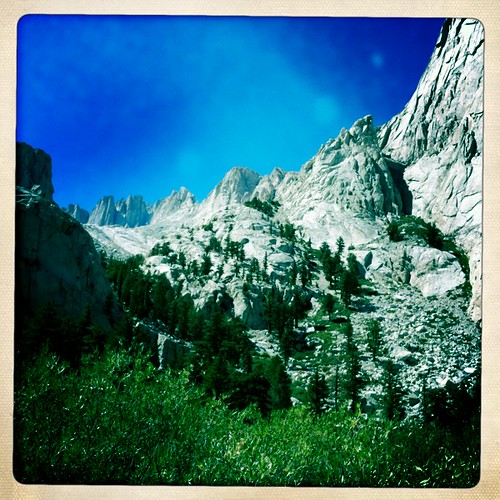
A billion calories and several dry socks later, we made our way up past Mirror Lake, and into the lunar territory above the tree line, scampering up granite slabs and steps, marveling at the High Sierra majesty looming in front of us. By the time we reached the thin sliver of Trailside Meadow, I was a bit fatigued and ready to set up camp, but the promise of sleeping in Whitney's shadow urged me on to Trail Camp, where we all collapsed on a sandy slab just south of tent city, with just enough energy to set up our windblown tents, load up several layers of clothing, and boil up some water.


Closing in on Consultation Lake & Trail Camp


It was here that I realized - I needed to go to the bathroom. By that, I mean - I needed to use the WAG bag. For the uninitiated, the WAG ("Waste alleviating and gelling" or "What?? Ahhh...gross!!!!!!") bag is a necessity on Mt. Whitney, due to the intense foot (and waste) traffic and the nature of the mountain itself - granite does not an in-ground toilet make.


We'd all hoped to escape using our WAG bags, but I knew my time had come. I stood and stared at my bag for a while, and then announced that I was going to find a comfortable spot. My trailmates stared incredulously - "You're going to go for it?" "We want a full report afterwards." "Good luck!"


Nervously, I gathered my supplies and headed toward a big hump of rock at the far side of camp, away from tents and people and water, shielded from the wind. I unwrapped the bag, spread it out on the ground, and stared at it. FOR A LONG TIME.


Shitting in a bag is not natural.

[THINGS I HATE #6 - SHITTING IN A BAG]


But I shat in a bag, coaxed into a vague state of relaxation by the incredibly gorgeous setting sun. In fact, it would have been incredibly picaresque...had I not been SHITTING INTO A BAG.


Somewhat satisfied, I returned to camp, my deposit quadruple-bagged, slung from my shoulder. I felt strangely proud, even more when my friends inquired about the WAG experience. I recounted my epic adventure, gave them the necessary precautions, then hid that damn bag under a rock far, far away from my tent. They say the double-bagging system prevents odor leaks, but "they" weren't with me somewhere around the 18-mile mark the next day.


Exhausted from my sojourn, I slept like a rock, on a rock, at 12,000'.


***


I woke up sometime in the late, late evening or early, early morning with a dull thud of a headache wrapped around my skull. Worried about needing to pee in the middle of the night, I stopped drinking water when we rolled into Trail Camp, a rookie mistake I'll never make again. I slammed ibuprofen, and curled up next to my Camelbak, slowly sipping until the dull thud transformed into a mild annoyance, and woke up at 3:15am ready to hit the trail.


Strangely, in those first few minutes of the pre-pre-pre-dawn morning, we were all moving fairly quickly - redressing, boiling water, sorting out our daypacks. For me, it was the excitement, the need to pee, and the magical tricks the nearly-full moon was executing across the range.


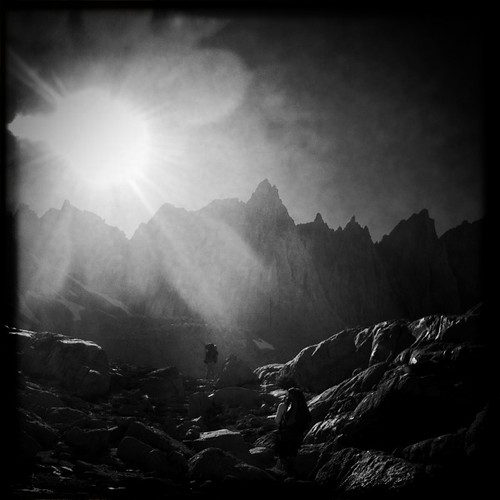
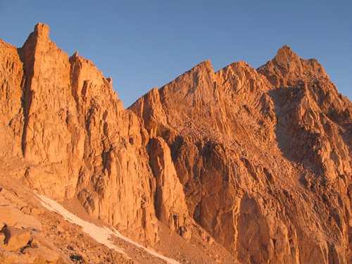
But then we crashed, and sluggishly choked down some oatmeal, sulking onto the trail in complete silence. But after a brief stop on the third or fourth switchback to remove a few unnecessary layers, we hit our stride. Laura suggested we turn off our headlamps, and so we did, guided quickly above Trail Camp by the light of the moon. We flicked on our lamps around a few icy spots (including the notorious cable section), and surprisingly quickly found ourselves on the homestretch of the infamous 99 switchbacks just as the dawn was breaking behind us. We stopped occasionally to watch the incredible alpenglow light show play out on Mt. Muir to our right, first a faint pink, then a deep salmon, and finally settling into an Oompa Loompa orange before the sun illuminated the sky - a visual experience I'll never forget.


Alpenglow rules!


When the sign for Trail Crest came into view, we practically bounded up to it. A few photos and a slightly demoralizing descent later, we were on the backside of the mountain, picking our way through a scramble of talus chunks, easily my least favorite part of the trail. Occasionally, I thought about what would happen if I fell straight down to Sequoia National Park below, but mostly I focused on counting the Windows (not bad at all, scaremongers!), and closing in on the backside of Keeler's Needle.


On the last mile to the summit, I realized that I would make it to the top. I slowly chugged along, wind-chapped, but thrilled, and finally saw Casey on the trail above me, working his way up the backside of the Whitney massif. I waved and he waited, and then we slowly picked our way up together.


Then the one thing the trip reports and speakers got right - the moment when you get just far enough up on the backside to see the Smithsonian Institute hut above you is a moment you'll never forget. Tears sprung into the corners of my eyes - in fact, they're threatening to well up there now as I write this. What an unforgettable, incredible, indelible moment. I couldn't believe it. I kind of still can't.


Summit hut, finally!


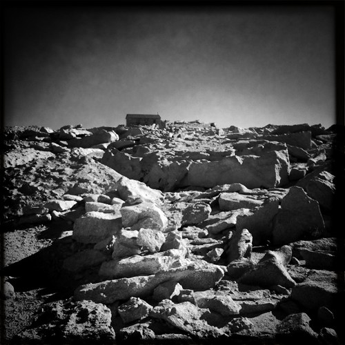
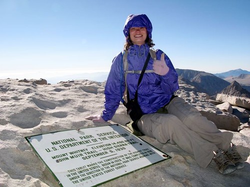
I slid my gloved hands across the rock walls of the hut as I walked past it, then found the summit plaque and laid down next to it. The only other people on the summit - 3 hikers we met at the start of our journey - were headed down, so it was just Casey and I for a few minutes, until Laura and Rebecca joined us. I had a a Titanic "king of the world" moment, and just laughed and laughed and laughed with joy. It was perfect.


I DID IT!!!!!!


***


The 11 miles back to Whitney Portal weren't my favorite in hiking history. The slight downhill on several talus sections was slightly heart-stopping, the 99 switchbacks seemed like 199, and the hard granite slabs and steps were a bit more jolting in reverse. [THINGS I HATE #7 - FALLING INTO THE ABYSS] [THINGS I HATE #8 - DOWNHILL] [THINGS I HATE #9 - CARRYING A BACKPACK] [THINGS I HATE #10 - CARRYING MY OWN SHIT IN A BAG] I felt fatigued, and the last few miles, nauseated, until I gave a sudden dry heave right at the John Muir Wilderness sign. And then we walked down and out, and right over to the Whitney Portal Store for one last epic meal.


***


In the week since returning from Whitney, I've relived every mile of trail, flipped through my photos more than a dozen times, and thought about how to process it all. I stood on top of the continental United States, something I dreamed of doing for a long time, something that almost seemed impossible to a girl who was afraid of the monkey bars as a kid.


I feel different, in a good way. It was a mental and physical challenge, spread well over a year in preparation. Whitney's been a part of my life all this time, and to finally have that communion on her rocky slopes and summit was undeniably triumphant. I think I truly understand that I really can do anything.


Anything.


Summit dance


PHOTOS

I have no idea why it's not showing the full photos - to view them in all of their glory:

http://www.flickr.com/photos/shawntesalabert/sets/72157624750186191/


What Would Ed Do?

I've said it before, I'll say it again - Ed would be proud. Damn proud.


[Shawnté]

Friday, July 9, 2010

Backpacking Preparations aka "Procrastination"


(This photo is unrelated to this post; I just know that people like to look at photos when they read blogs. I took this in Olympic National Park almost four years ago. Enjoy.)

I just returned home from an angst-ridden viewing of what may only be described as an epic, timeless love tale for the ages - Eclipse (aka the third Twilight film). Movie night was an early birthday gift from my friend, although whether or not this was truly a "gift" is probably up for debate.

In the morning, I'm heading off on a mini backpacking trip to the Cucamonga Wilderness. I figured that packing might be a good task to accomplish this evening, a perfect way to rinse away the ten metric tons of sparkly vampire schmaltz vomited out of the screen tonight.

But I am not packing. I'm writing a blog. And before writing this blog, I was laughing my way through this amazing website. And before that, I was eating some delicious Trader Joe's Irish Cheddar With Porter and Trader Joe's Original Savory Thins rice crackers, two things that were supposed to be part of my trail lunch tomorrow. Oops. I guess I'll be going to Trader Joe's in the morning. 

Oh yes, packing. 

As I am still mulling the lessons learned from the Yosemite backpacking trip two weekends ago, I don't exactly have high hopes for myself in this department. I'll leave the deodorant at home this time, but I'm still tempted to bring the playing cards (what if we get bored?), the newest issue of New York (it's thin, plus there's a crossword puzzle; see "what if we get bored?" above), and a tiny pillow (I sleep best when my head is cradled in a soft billow of fluff; easier to pretend I'm at home in bed instead of splayed on the side of a mountain, masquerading as bear bait). 

I am, however, very excited to pack my brand new sleeping pad, purchased last night at the Santa Monica REI. I nearly punched an entire parking structure in the face once I realized that a) it was $5 to park, even though I would only be in the store for maybe 20 minutes, and b) there were no available spots to park in the damn structure, even after circling around for 10 precious could-be-buying-overpriced-and-vaguely-unnecessary-outdoorsy-things-at-REI minutes. 

But I made it to the store, with 25 minutes to shop. I bee-lined for the sleeping pad section, wherein I proceeded to find every inflated pad marked "Women's," and threw them all on the floor, commandeering the entire back corner of the store. Then I systematically began a complicated process that involved flopping on my stomach, rolling onto my side, propping myself up on one elbow, kneeling, then rolling onto my back. I went through three pads before I realized I had an audience in an overzealous sales dude whose name I didn't register.

"Hi, I'm (insert generic sales dude name)! Can I help you with anything?" he asked as I gently spooned the generic REI Trekker Self-Inflating Sleeping Pad-Women's Regular*. Strangely, I didn't feel compelled to move or assume a less risqué position when answering him. "No, thanks - just getting a new sleeping pad." This, of course, served as an invitation for him to stay there and prattle on about each one as I systematically continued my testing. When I finally selected the Therm-A-Rest of my dreams (aka budget), we said our goodbyes (him, somewhat reluctantly) and I left with the slightly off-putting feeling that he got a whole lot more out of the exchange than I did.

Oh, right - packing. I'll probably just do that in the morning.


* This, along with many of the "Women's" options, was purple. I DON'T WANT PURPLE CAMPING GEAR.  Just because I have a uterus doesn't mean I want my tent to look like a goddamn sorority house.


What Would Ed Do?
Ed is a combination sherpa/pack mule/MacGyver. Ed could beat my pretend husband, Survivorman and that jokey Man Vs. Wild dude in a cage match, and is probably equipped to survive in the wild on nothing more than granite dust and slugs. But if he needed a sleeping pad, he could probably kill, gut, and skin a wild boar, then inflate its pelt for a good night's sleep.

[Shawnté]

Sunday, June 20, 2010

Telegraph Peak via Icehouse Canyon aka "Deception Peak"

View of Mt. Baldy from atop Telegraph Peak


Hike(s): Icehouse Canyon to Telegraph Peak

The Inspiration: The allure of the 3 T's

Highest Altitude: 8,985'

Trip(s) Mileage: 13.8

Total 2010 Mileage: 100.6


Telegraph Peak is quite the deceptive little ballbuster. 


The plan was for Team WWED? + Modern Hiker to stroll through Icehouse Canyon and head for the Three T's trail from the Icehouse Saddle, passing by Timber and topping out on Telegraph. Which we did. But it proved a bit more labor-intensive than any of us initially thought.


Arriving at the ranger station before the hike, we grabbed our wilderness permit and were duly informed that there was a hungry and very social little bear hanging out around the trail. Where?, we asked. The ranger very helpfully circled the trailhead, then made a big red asterisk right next to it.  Right there. At the beginning of the trail. Oh.


We practiced our bear-scaring measures (stomp loudly, clap loudly, repeat) and sped past the trailhead, continuing warp speed ahead, dodging slow trekkers left and right, rushing past an incredibly full flow of water, making record time to the Cucamonga Wilderness boundary. And then we all panted. And panted some more. Slow and steady does win the race when the race is more like a nearly 14-mile marathon. Lesson learned.


We carried on, tromping relatively quickly up the never-ending switchbacks to the saddle, passing a gushing double-decker waterfall in the canyon's crease. (Note to readers: Go to Icehouse Canyon NOW. Winter snowmelt = massive amounts of water everywhere. Bonus!)


At the saddle, we recharged, a mix of cold pizza, Clif bars, trail mix, and ginger chews fortifying us for the next set of quick switchbacks up towards Timber, and a surely quick 2.2 mile jaunt to Telegraph.


Ha. Bwahahahahahahahahahahaha!  Quick 2.2 mile jaunt, my ass!


At the junction with the Timber Mtn. spur trail, the Three T's trail continues towards Telegraph, and quickly descends to a very, very windswept saddle at about 7740'. Of course, we knew we'd have to climb back up to reach Telegraph, but we had no idea just how much elevation we lost on the way down from Timber. It was only afterwards that we realized that we put ourselves through 1,245' of elevation gain in just over a mile. 


During said mile, I cursed. I mumbled things under my breath. I considered finding a new hobby. It was a very, very, very silent mile. A very, very, very shitty mile. 


At what felt like the 666th switchback, we came across a group of people descending, with a few of them opting to cut across said switchback. Prompted by general crankiness, my inner self-righteous hiker asshole blurted out, "You know, you're not supposed to cut the switchbacks. It ruins the trail." The offending hiker retorted with, "Well, we're good hikers and we wouldn't cut the trail, except there's snow on it." I looked over. There was definitely snow on the trail. 


Telegraph Peak was turning me into an asshole. I needed to take a rest. I considered the possibility of scooting down the mountain on my butt. I considered the possibility of continuing on to Thunder and taking the ski lift down. I considered stopping at that very switchback and taking a nap, but I found myself nervously tromping across the snow and back up the damn mountain. 


When we reached a luxuriously wide and vaguely forested saddle, we all sat down, fueled up, and I proclaimed that I was done with this jerky portion of the hike and would be sitting out the last chunk to the top. Then we looked at the map, and the map said that it was only 0.1 miles to the top, and I bucked myself up for the last haul. 


Once on top, I realized that Telegraph Peak was not as assholey as I thought - it was just very, very picky. It wasn't going to let just anyone stake a claim - you had to earn your way. I felt proud. I soaked in the 360 degree views of Baldy, Cucamonga, San Jacinto, San Gorgonio, and beyond. Then I ate 4 slices of well-earned cold (well...lukewarm) pizza.


The mile or so back to the saddle was relatively uneventful (save for my constant fear of losing my balance and pitching myself thousands of feet down off the mountain during some hairy parts). It didn't seem nearly as steep, nor as exhausting, though the climb back up Timber was a minor pain in the ass. But as we gained momentum and busted our knees sailing down past Icehouse Saddle, through the canyon, and back to the car, I think we all felt a sense of pride in earning our spots atop Telegraph Peak. 


And then we went to Baldy Lodge and scarfed down burgers and fries and sugary drinks, a worthy prize for such a worthy endeavor. 


What Would Ed Do?

Ed would take Icehouse Canyon up through the Three T's, across Baldy, then hop in the car and tag San Gorgonio just for fun. Ed would, however, be proud of our camel-like abilities to collectively carry something like 11 liters of water on this trip. 


[Shawnté]

Sunday, June 6, 2010

3 Months 'Til Whitney aka "And So It Begins"


Hike(s): Batcave/Hollywood Sign/Mt. Wilson/Temescal-Will Rogers-Topanga Loop

The Inspiration: Mt. Whitney prep

Highest Altitude: 5,712'

Trip(s) Mileage: 35.6

Total 2010 Mileage: 86.8


And so it begins. 


In less than three months, Team WWED? and Modern Hiker (joined by Good Ranger Laura) will (hopefully) stand proudly atop the highest point in the continental United States - the grand diva herself, Mt. Whitney (that's Ms. Whitney, if you're nasty).


So we must condition ourselves and prepare our bodies to be the best high-altitude summit-seeking machines they can be. This training entails the following:


1) Miles. Lots of them. In a row. Without the aid of motorized vehicles.

2) Altitude. Lots of it. Progressively higher. Without vomiting.

3) Swedish Fish*. Lots of them. And then more of them.


As a little wake-up call to our legs, Team WWED? + MH began pre-conditioning in mid-May by playing tourist for a warm-up 6.6 mile jaunt, ducking into the Bronson Caves (aka Batmobile Garage), then searing our calves en route to the top of the Hollywood Sign. 


The following weekend, confident in our abilities, we led a full-on masochistic assault on our bodies, a sweaty, energy-sapping, ab-engaging, knee-breaking 15-mile cross-ridge loop from Chantry Flat to Mt. Wilson and back. Not three minutes in to said adventure, MH already had us bushwhacking up a poison oak-laden firebreak that nearly rivals the (lovingly) dreaded Chumash trail (for the record, that's the one that boasts a lovely 845' gain in 0.7 miles, straight off of PCH to the La Jolla Valley). 


After emerging from the second of these lovely scrambles, we caught the last hairpin turn on the San Olene Fire Road and hopped up on the Santa Anita Ridge firebreak - aka NOT A REAL TRAIL. But we knew this going in, and MH assured us he'd done this trail (albeit mistakenly) before - and he's a hiker of his word. 


Now, if you're reading this and thinking, "Well, I'd really like to do something painful to my legs today," I have just the solution for you - hike the Santa Anita Ridge firebreak. This sucker is no joke - up, down, up, down, up, down, up, down, for what felt like an eternity. There were a few slips, a few slides, and a few times when I found myself on hands and knees - but you know what? Once it was over and we were back on the real trail, I realized that I must have a slightly masochistic streak, because it was a hell of a lot of fun (at least until I woke up the next day unable to walk properly).


Less than a week later, Rebecca and I decided that since we'd already begun the pre-Whitney physical beatings, why not carry on, but with significantly less firebreak madness, so we headed off to Temescal Canyon to begin a 14-mile loop that quickly led us up and out of Temescal into Will Rogers State Park, then on a very overgrown, bee-and-fly-ridden trail around the bend of a canyon, which took us through Topanga State Park, and then back into Temescal. This time, 14 miles didn't feel so rough.


And so it began. And so it will continue, all summer long, until we've ascended the infamous 99 switchbacks, passed quickly across the dreaded "windows," and find ourselves on top of the (continental) U.S., full of Swedish Fish and enjoying the biggest natural high I've ever imagined.**


*Swedish Fish is the unofficial energy snack unofficially endorsed by Team WWED? We highly recommend the traditional red variety, also good for trail-marking when in a pinch.


**Until the next big adventure...


What Would Ed Do?

Ed would do quadruple the miles at triple the altitude, but then again, Ed has major sponsorships and time at his beck and call; we have finite paychecks and jobs.


[Shawnté]

Thursday, April 22, 2010

Backbone Trail Redux aka "VICTORY!"


Hike: Backbone Trail - Corral Canyon to Castro Crest

The Inspiration: Stubbornness

Highest Altitude: 2,250'

Trip Mileage: 6.6

Total 2010 Mileage: 57.8


Last weekend, Rebecca and I set out to avenge our misguided journey on the Santa Monica Mountains Illicit Drug Trail, hoping that if we started at the Corral Canyon parking lot entrance to the Backbone Trail, we could retrace our steps and figure out what in the holy hell went wrong back there.


Legs stretched, packs fastened, and sheer determination at full throttle, we quickly wound our way down to the canyon floor, leaving a few lumpy cairns in our wake, lest we end up in Meth Lab Valley once more.


We took our time wandering underneath a thick canopy of greenery, crossing a shallow creek eight or nine times, emerging at one point in the mist of a mini-Manservant Meadow (I'll explain that some other time), where we later spotted this phallic, yet adorable piece of work:


Not a care on our minds besides finding the damn effing damn mothersucking effing other side of the Backbone Trail by the Castro Crest, we sauntered through the thick foliage, until we heard an utterly frightening noise. We both froze.


My inner monologue: Is that a woman being attacked in the woods? I'm really starting to hate the Backbone Trail.


Rebecca looked at me.

I looked at her.

Then the godawful sound happened again.


"Oh, that's just a bird," I say, ignoring my inner monologue.


"Well, it sounds like maybe a baby mountain lion being mauled to death," says Rebecca, clearly in tune with her own inner monologue.


"Just a bird," I mutter, and unconvinced, we barely restrain ourselves from running as fast as humanly possible away from the sound...until we hear another sound.


Ohmygod, it'scomingforusandit'sgoingtokillusandwe'regoingtodieonthiseffingdamneffingtrail.


Oh, nevermind. Just some people hiking with a dog. Perhaps I should lay off the Lost marathons for a while.


Without trying, we've both summoned up the maximum levels of adrenaline permissible in the human body, and we hightail it up the trail until we come to it...the other end.


Wait a minute. Waiiiiiiiiit a minute. I know where we are. And I know how we completely missed this the first time - see photo below:


Pretend you're walking straight ahead, facing East in this photo, towards that humpy thing in the background. Do you see a trail turnoff? No, neither did we. So we kept walking due East, towards the humpy thing, and that is how we ended up on the Santa Monica Mountains Illicit Drug Trail.


Now look a little closer at the left side of the photo - do you see a wee little itty witty bitty area that maaaaaaybe might be something? Yeah, that's a 90-degree turn in the trail that's unmarked and pretty easy to miss when you have a large humpy thing distracting you straight ahead.


Now you know.

And so do we.


What Would Ed Do?

Ed would not be distracted by humpy things in the distance - Ed would look around at his surroundings just a weeeeee bit. Also, Ed would have saved us both from certain death by the woman/baby mountain lion-mauling machine lurking out in the forest.


[Shawnté]

Saturday, April 17, 2010

Latigo Canyon-Castro Crest aka "Meth Lab Motorway"


Hike: Backbone Trail (Latigo Canyon Rd. to Castro Crest to Meth Lab City)

The Inspiration: Our maniacal urge to complete the Backbone Trail in its entirety, segment by segment

Highest Altitude: 2,250'? Who the eff knows!

Trip Mileage: 5.0...ish

Total 2010 Mileage: 51.2*


I met my outdoor nemesis and it is the segment of the Backbone Trail that begins at Castro Crest and winds down to Corral Canyon Road.


Please allow me to explain.


Caffeinated, Rebecca and I flew down the 101 last weekend, excitedly heading for the junction of the Backbone Trail and Latigo Canyon Road. According to the P-circle on our handy waterproof Tom Harrison map, we were looking for a real parking area. Something defined. Maybe signed.


Or maybe not. Maybe we turned around TWICE in two very inopportune, barely two-lane-width areas on Latigo Canyon Road, me cursing in a progressively more audible way, Rebecca gritting her teeth in a progressively more audible way, totally unable to locate said Harrison Map P-circled parking lot.


Several curses, teeth grinds, and less-geographically-challenged cyclists later, we found said P-circle, parked, and fired ourselves back up. The Backbone Trail! WE'RE GONNA DO IT! RARRRRRR!


We found ourselves down in a lush, green canyon of sorts, rife with purple-y, pink-y wildflowers, split by a trickling stream. Despite hopping off-trail a few times to avoid being flattened by several maniacal cyclists, we were having a damn swell time. We LOVED the Backbone Trail!


Several cyclist-dodgings and a small bit of climb later, we emerged on a fire road in the Castro Crest section of the Santa Monicas. One option was to go left, which according to two dog-walking know-it-alls was a bad idea, since there was a private gate a half mile up.


We shrugged. It did not matter. The Only Thing That Mattered Was Continuing On The Illustrious Backbone Trail, Full Of Wildflowery Beauty And Lush Green Fantasyland.


We turned right on the fire road. At a fork, the dog-walking know-it-alls ascended the road to the right. We descended to the left, on the well-marked Backbone Trail, dodged a few more cyclists, and took in the epic valley view. One of us might have said "I love this trail."


One of us might have regretted that a short time later.


Continuing our descent, we suddenly found ourselves faced with what can only be described as a tightly-knit thicket of bramble crap. I said something about how the recent rains must have stimulated some growth in the area, wondered for a moment how all of the renegade cyclists must have a hard time navigating this area, and then plowed right through, logic be damned.


Ow. Yowch! Grrr. Ouch!...pfffft.


"Hm, do you think this is really the right way?" one of us might have voiced.


"Yeah, of course. I mean, we followed the Backbone Trail sign,right?" one of us might have responded.


Once we fought our way through the mess, we faced a conundrum. To the far left was a dry riverbed of sorts, just right of that was a grassy bump, and then a fork in the fire road. We consulted our handy Tom Harrison map. Then I made the fateful decision to follow the left fork of the fire road, in the hopes that it was the Backbone Trail, and we would end up at the far end, Victorious!!!


But I was wrong. So. Totally. Wrong. We suddenly found ourselves stomping our feet and wading through knee-deep weedy grasses, making our best attempt at scaring off lurking snakes. We consulted the trusty Tom Harrison a few more times. We stopped and took a photo of a tennis ball jammed into a dead bush. We skirted fallen trees. And we think we stumbled upon some meth labs.


We were most definitely NOT on the Backbone Trail. We came to a high spot and broke out ole Tommy H. We used our compass. We knew North, South, East, and West. But we weren't on the map. Tommy was of no use. We were in the wilds.


We were also probably not too far from this.


We considered the possibility that someone from the sure-to-be meth labs might come out and shoot us. We finally turned around.


Curious as to how our spidey senses, T-Harr, and the official Backbone Trail signage could have pointed us towards certain death on the Santa Monica Mountains Illicit Drug Trail, we retraced our steps and considered the options we first encountered when we emerged from the scratchy thicket:


1) Dry riverbed - NOPE. This was not the Backbone Trail. This was a dry damn riverbed that suddenly fell deeper into the canyon.


2) Grassy bumpy thing - MAYBE? I ran up and scouted the area. I thought I saw a trail. Maybe. Well, definitely. But whether or not it came from here...I do not know.


3) Left fork - NOPE. GUN-TOTING MADMAN METH LAB CENTRAL.


4) Right fork - Aw, the hell with it. Let's go home.


We WILL return, Backbone Trail. We will find you, and we will triumph. TRIUMPH, I SAY!!!


* Yes, the milage jumped quite a bit between the last posted hike and this entry. That is because I've been a hike-posting slacker, and in the interim, Rebecca and I have completed jaunts down into Hondo Canyon, around the Temescal Canyon Loop, and over to Eaton Canyon Falls, which maybe I'll write about if I'm not completely sidetracked by the 5 seasons of Lost my co-worker recently bequeathed me.


What Would Ed Do?

Ed would have turned around at the first sign of off-trail bushwhacking and/or possible meth lab activity. However, please allow us to redeem some points here because Ed would be proud that we not only used a map and compass together, but used them correctly together.


[Shawnté]

Saturday, January 30, 2010

Sandstone Peak 2 aka "Mud Bath Trail"


Hike: Sandstone Peak via the Backbone & Mishe Mokwa Trails

The Inspiration: Memories of our last trip to Sandstone Peak; the promise of post-rain water everywhere!

Highest Altitude: 3,111'

Trip Mileage: 6.6

Total 2010 Mileage: 28.6

The recent-ish spate of wet weather here in SoCal prompted a return trip to one of our favorite trails in the Santa Monica Mountains - the Mishe Mokwa Trail to Sandstone Peak. This was actually the first trail Rebecca and I trod on together, and it was time for some re-treading, full of anticipation for the wet wonderland surely laid out before us.

Joined by Casey and Kolby, we tightened the ole bootstrings and began the muddy hike in from the Backbone Trail.

The very muddy hike in.

The very very muddy hike in.

I blurted out, "This is kind of like walking in poop."

Rebecca looked back at me, clearly disgusted.

I continued on, anyways, brain-to-mouth filter broken for the moment: "Yeah, just the color and the consistency and everything. Totally like walking in poop."

We carried on in silence.

Whilst I quietly and perversely contemplated the position of this particular mud on the Human Waste Color/Consistency Continuum, the landscape opened up like a fresh post-rain bloom all around us - the snow-capped mountains of the Los Padres National Forest, the newly greened hills cleaving into canyons drenched in rainwater, the almost unnaturally blue skies…

Even once we hit the familiar Mishe Mokwa Trail, it was all new again – the trail turned into an active creekbed and mini waterfalls tracked down the sides of cliffs like so many Smokey Robinson tears, the unfamiliar sound of gurgling water bouncing off of echo-fed walls.

Not too shabby. Any and all mud-poop comparisons totally left the building.

The rest of the hike was just really, really fantastic, and if anything, it was a reminder that mother nature isn’t static; even in a place with the kind of weather predictability that leaves potential retirees foaming at the mouth, she can throw a curveball and leave us slack-jawed and giddy like schoolchildren skipping through fresh puddles on sidewalks we thought were nothing but concrete.

What Would Ed Do?

Ed would have worn gaiters, and for that, Ed is a smart, smart man.

[Shawnté]